Learning Intention: to understand that bush fires and floods are natural hazards that have wide spread impacts on the community.
|
Success Criteria:
|
A natural hazard is a naturally occurring event that has a negative effect on people or the environment.
|
Bush fires can be caused by lightning, deliberately lit or started accidentally. |
What is a bushfire?
A bushfire is a fire that burns in grass, bush or woodland and can threaten life, property and the environment. Unlike the common practice of back burning, wildfires or bush fires are fires that are unmanaged and burn uncontrollably. A bushfire can burn quickly and be devastating if not detected and extinguished. In the drier seasons, the dangers of a bushfire occurring are very high. A bushfire can destroy homes and buildings, devastate crops, and threaten the lives of people and animals. 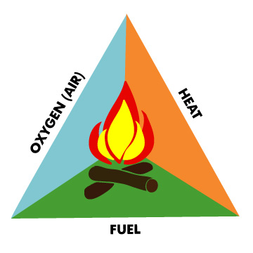
|
|
Environmental impacts
A bushfire is one that affects the environment in both good and bad ways. On the one hand the fire is beneficial. Some plants use the conditions provided by the blaze to germinate and while other plants that burn down have adapted to survive, as have the animals that use them as a habitat. On the other hand, bush fires can have dire consequences for the environment including loss of flora and fauna. |
|
|
|
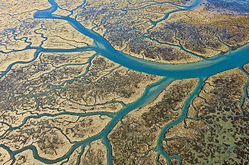
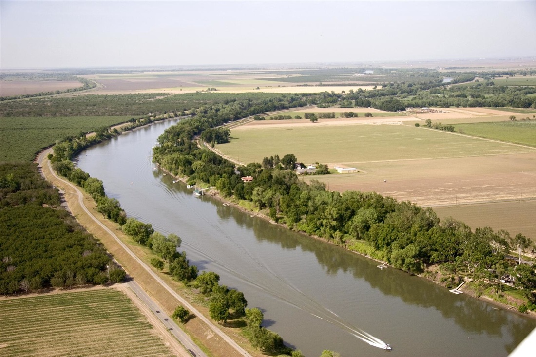
A flood is a temporary covering by water of land not normally covered by water.
|
|
Although floods can be devastating to communities, it is an essential part of nature's renewal process, providing many long-term positive effects.
Some positive effects of floods are: - Distribution of rich sediment that returns nutrients to the soil and replenishes wetlands. - Allows new vegetation to grow on eroded river banks. - Provides new habitats to river organisms in the form of natural debris. - The surrounding soil may receive a boost in fertility allowing new plants to germinate. |

|
Learning Intention: to explain the causes and identify locations of flooding in Australia.
|
Success Criteria:
|
|
|
|
Glossary
|
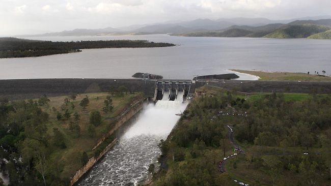
Floodplain: low lying area surrounding a river that is prone to flooding. Tributary: is a stream or river that flows into a larger stream, river or lake. Dam: a barrier constructed to hold back water. This water forms a reservoir (an artificial lake) which can be used to generate electricity or as a water supply. Levee: a wall or bank of earth or stone built to prevent a river flooding an area. |
|
Use Google Maps to help you map the following floods in Australia. When you have mapped the flood locations you need decide whether it was a minor, moderate or severe flood incident. What trends or patterns have you found?
1. June 1852 - Gundagai, NSW
89 deaths, entire settlement of 250 people destroyed
There's little doubt that the 2010/2011 Queensland floods were Australia's most devastating in terms of damage to infrastructure and cost, but the worst loss of life happened in June 1852 when massive flooding on the Murrumbidgee River swept away most of the town of Gundagai, leaving just three houses standing. Eighty-nine people were killed, more than third of the population. The town was later rebuilt on higher ground.
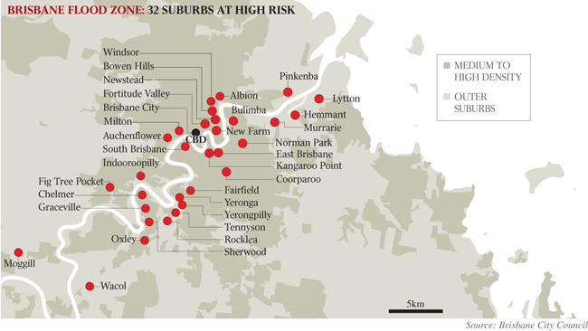
2. Dec 2010 - Jan 2011 - Brisbane and SE QLD
35 confirmed deaths, $2.38 billion in damage
With more than 200,000 people affected state-wide, the economic damage from this flood was estimated at $2.38 billion. Beginning with rains in September and then culminating with Category 1 Cyclone Tasha crossing the Far North Queensland coast on 24 December 2011, this was probably the most notorious flood in Australian history. In Brisbane, the river peaked at 4.46m on 13 January, flooding more than 28,000 homes and leaving 100,000 without power. Cyclone Yasi, which hit 3 Feburary, caused further damage to already sodden towns.
3. Dec 27, 1916 - Clermont and Peak Downs, QLD65 deaths, 10 homes destroyed, 50 buildings damaged and 10,000 livestock killed
A cyclone swept the coast along the Whitsunday Passage, bringing heavy rainfall to Clermont, Sapphire and Peak Downs. This usually flood-savvy town forgot to counter for the runoff from nearby catchments and creeks and the debris it carried with it at crushing speeds. The torrent smashed through houses and caused widespread damage. The lower part of Clermont was submerged, so the town was rebuilt on higher ground.
4. Nov 29, 1934 - Melbourne, VIC36 deaths, 6000 homeless and 400+ buildings damaged
In late November 140mm of rain fell in Melbourne over a 48-hour period. To the east of Melbourne, in South Gippsland, 350mm fell over the same two-day period. The downpour resulted in landslides, evacuations and many submerged roads. Eighteen people drowned, with a further 18 killed by collapsing buildings and other dangers. More than 400 buildings were damaged in Melbourne and 6000 people were left homeless.
5. Feb 15, 1893 - Ipswich, QLD35 deaths, 300 people injured and two bridges destroyed
Often referred to as the Black February Flood, the extreme weather conditions and heavy rain were brought about by tropical Cyclone Bundinyong. The Crohamhurst weather station recorded 914mm of rain in a 24-hour period and another gauge recorded almost 889mm of rainfall in Brisbane's water catchments. Both the Victoria Bridge and the Indooroopilly railway bridge collapsed, with 35 people killed and 300 injured.
6. Feb 1927 - Brisbane, Cairns, Townsville, QLD47 deaths, 16 homes destroyed, an estimated £300,000 in damages
A tropical cyclone hit north of Cairns, causing major rainfall through Queensland, reaching as far as Toowoomba. The torrential rain, which fell from 9-17 February, led to the deaths of 47 people, damaged roads, railways, bridges and buildings - and completely destroyed 16 houses. There was also widespread loss of livestock. The estimated costs reported at the time were in the region of £300,000.
7. Apr 1929 - Northern Tasmania22 deaths, 1000 homes damaged, 25 bridges destroyed
The area of Northern Tasmania is prone to heavy rainfall over short periods and up to 500mm of rain fell over three days. The floodwater carved a path across the region, destroying everything in its path, including vehicles, buildings and railroad tracks. It inflicted huge stock losses, the evacuation of 3500 people, while damaging 35 bridges and 1000 homes.
8. Feb 1955 - Hunter Valley, NSW24 deaths, 59 homes destroyed, 5200 homes flooded and 40,000+ people evacuated
The majority of deaths were around Singleton and Maitland, but most other river systems in the state were also in flood. These floods in the Hunter Valley have become symbolic in the Australian psyche of the dramatic nature of flood damage and rescue. About 15,000 people were evacuated from around these two towns, with more than 40,000 people being evacuated from a total of 40 towns. Five of the lives lost were due to electrocution during rescue operations.
9. Jan - Apr 1974 - Brisbane, QLD14 deaths, 300 injured, 56 homes destroyed, an estimated $68 million in damages
After a particularly wet year in 1973, Brisbane was inundated with water when tropical cyclone Wanda hit the north of the city on 25 January 1974. By 29 January the Brisbane area had recorded 900mm of rain, with 314mm of rain falling in a 24-hour period. In the coming months the torrential rain swept down the east coast, causing floods in parts of NSW and Tasmania. The floods killed 14 people and injured 300 more, as well as destroying 56 homes and damaging 6000 others. In all, an estimated $68 million worth of damages occurred.
10. Aug 1986 - Hawkesbury and Georges River Flood, NSW6 dead, 10,000 homes damaged, an estimated $35M in damages.
With the rainfall reaching 327.6mm in 24 hours, this day has been dubbed Sydney's wettest day ever. The torrential rain created chaos, with flooded roads prompting many motorists to abandon their cars. Bus services were severely disrupted in the city and trains were halted due to flooded tunnels.
1. June 1852 - Gundagai, NSW
89 deaths, entire settlement of 250 people destroyed
There's little doubt that the 2010/2011 Queensland floods were Australia's most devastating in terms of damage to infrastructure and cost, but the worst loss of life happened in June 1852 when massive flooding on the Murrumbidgee River swept away most of the town of Gundagai, leaving just three houses standing. Eighty-nine people were killed, more than third of the population. The town was later rebuilt on higher ground.
2. Dec 2010 - Jan 2011 - Brisbane and SE QLD
35 confirmed deaths, $2.38 billion in damage
With more than 200,000 people affected state-wide, the economic damage from this flood was estimated at $2.38 billion. Beginning with rains in September and then culminating with Category 1 Cyclone Tasha crossing the Far North Queensland coast on 24 December 2011, this was probably the most notorious flood in Australian history. In Brisbane, the river peaked at 4.46m on 13 January, flooding more than 28,000 homes and leaving 100,000 without power. Cyclone Yasi, which hit 3 Feburary, caused further damage to already sodden towns.
3. Dec 27, 1916 - Clermont and Peak Downs, QLD65 deaths, 10 homes destroyed, 50 buildings damaged and 10,000 livestock killed
A cyclone swept the coast along the Whitsunday Passage, bringing heavy rainfall to Clermont, Sapphire and Peak Downs. This usually flood-savvy town forgot to counter for the runoff from nearby catchments and creeks and the debris it carried with it at crushing speeds. The torrent smashed through houses and caused widespread damage. The lower part of Clermont was submerged, so the town was rebuilt on higher ground.
4. Nov 29, 1934 - Melbourne, VIC36 deaths, 6000 homeless and 400+ buildings damaged
In late November 140mm of rain fell in Melbourne over a 48-hour period. To the east of Melbourne, in South Gippsland, 350mm fell over the same two-day period. The downpour resulted in landslides, evacuations and many submerged roads. Eighteen people drowned, with a further 18 killed by collapsing buildings and other dangers. More than 400 buildings were damaged in Melbourne and 6000 people were left homeless.
5. Feb 15, 1893 - Ipswich, QLD35 deaths, 300 people injured and two bridges destroyed
Often referred to as the Black February Flood, the extreme weather conditions and heavy rain were brought about by tropical Cyclone Bundinyong. The Crohamhurst weather station recorded 914mm of rain in a 24-hour period and another gauge recorded almost 889mm of rainfall in Brisbane's water catchments. Both the Victoria Bridge and the Indooroopilly railway bridge collapsed, with 35 people killed and 300 injured.
6. Feb 1927 - Brisbane, Cairns, Townsville, QLD47 deaths, 16 homes destroyed, an estimated £300,000 in damages
A tropical cyclone hit north of Cairns, causing major rainfall through Queensland, reaching as far as Toowoomba. The torrential rain, which fell from 9-17 February, led to the deaths of 47 people, damaged roads, railways, bridges and buildings - and completely destroyed 16 houses. There was also widespread loss of livestock. The estimated costs reported at the time were in the region of £300,000.
7. Apr 1929 - Northern Tasmania22 deaths, 1000 homes damaged, 25 bridges destroyed
The area of Northern Tasmania is prone to heavy rainfall over short periods and up to 500mm of rain fell over three days. The floodwater carved a path across the region, destroying everything in its path, including vehicles, buildings and railroad tracks. It inflicted huge stock losses, the evacuation of 3500 people, while damaging 35 bridges and 1000 homes.
8. Feb 1955 - Hunter Valley, NSW24 deaths, 59 homes destroyed, 5200 homes flooded and 40,000+ people evacuated
The majority of deaths were around Singleton and Maitland, but most other river systems in the state were also in flood. These floods in the Hunter Valley have become symbolic in the Australian psyche of the dramatic nature of flood damage and rescue. About 15,000 people were evacuated from around these two towns, with more than 40,000 people being evacuated from a total of 40 towns. Five of the lives lost were due to electrocution during rescue operations.
9. Jan - Apr 1974 - Brisbane, QLD14 deaths, 300 injured, 56 homes destroyed, an estimated $68 million in damages
After a particularly wet year in 1973, Brisbane was inundated with water when tropical cyclone Wanda hit the north of the city on 25 January 1974. By 29 January the Brisbane area had recorded 900mm of rain, with 314mm of rain falling in a 24-hour period. In the coming months the torrential rain swept down the east coast, causing floods in parts of NSW and Tasmania. The floods killed 14 people and injured 300 more, as well as destroying 56 homes and damaging 6000 others. In all, an estimated $68 million worth of damages occurred.
10. Aug 1986 - Hawkesbury and Georges River Flood, NSW6 dead, 10,000 homes damaged, an estimated $35M in damages.
With the rainfall reaching 327.6mm in 24 hours, this day has been dubbed Sydney's wettest day ever. The torrential rain created chaos, with flooded roads prompting many motorists to abandon their cars. Bus services were severely disrupted in the city and trains were halted due to flooded tunnels.
Learning Intention: to be able to explain causes of bushfires and identify their impacts on a community.
Success Criteria:
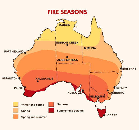
- I can identify the locations and seasons that bushfires occur in on a map.
- I can identify the conditions needed for a bushfire to occur.
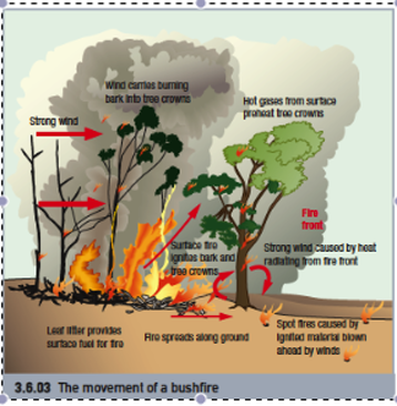
- I can explain how wind, heat and embers cause a bushfire to spread rapidly.
- I can explain and draw the cycle of a bushfire.
- I can explain the impacts bushfires have on a community.
Success Criteria:
- I can identify the locations and seasons that bushfires occur in on a map.
- I can identify the conditions needed for a bushfire to occur.
- I can explain how wind, heat and embers cause a bushfire to spread rapidly.
- I can explain and draw the cycle of a bushfire.
- I can explain the impacts bushfires have on a community.
|
BUSHFIRE CONDITIONS
Hot, windy and dry conditions are ideal for bushfires. Ignition: For fires to start they need an ignition source. Fuel: This refers to the grass and trees in an area that could be burnt to fuel the fire. Heat: Hot conditions dry out grasses, making them much more likely to burn. Wind: Strong winds give the fire oxygen. They carry embers long distances and drive the direction and speed that fires travel |
|
Learning intention: to be able to research and identify strategies that prepare, prevent and mitigate the harmful effects of bushfires and flooding.
Success Criteria:
- I am able to identify where information can be accessed about flood and bushfire warnings and locations.
- I can identify and record preventative strategies that should be completed before a bushfire or flood occurs.
- I can identify and record safety strategies that mitigate the harmful effects that occur during a bushfire or flood.
- I can identify and record safety strategies that should be completed after a flood.
Prevention: the action of stopping something from happening or arising
Mitigation: the action of reducing the severity, seriousness, or painfulness of something.
Preparedness: the action or process of preparing or being prepared for use or consideration.
Mitigation: the action of reducing the severity, seriousness, or painfulness of something.
Preparedness: the action or process of preparing or being prepared for use or consideration.
Information about warning systems and where to find flood and bushfire information HERE!
Information about flood prevention, mitigation and preparation HERE!
Information about bushfire prevention, mitigation and preparation HERE!
Information about flood prevention, mitigation and preparation HERE!
Information about bushfire prevention, mitigation and preparation HERE!
|
|
|
|
|
|
